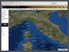
Satellite image maps (large scale prints)
Atlogis satellite image maps are high-quality
digital large scale prints of our 15m Landsat 7 satellite images combined
with vector data. Ideal for planning and navigation of travels or expeditions.

• World-wide coverage, selection via Atlogis-Maps
• Format sizes in DIN A0, A1 und A2
• Scales 1: 100.000, 1: 200.000, 1: 500.000,
1: 1.000.000
• Robust paper (on demand also laminated)
• Grid in WGS84 (ideal for GPS-navigation,
on demand also other projections/datums)
• Legend and overview map
• Integration of custom GPS-data (e.g. tracks,
waypoints) is possible
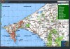
• Integration of Atlogis vector data, like
country-, city-, lake-, river- and mountain-names, borders, contour lines,
e.t.c.
The printed satellite maps are similar to the Hybrid-Layer on Atlogis-Maps
. Please use our Mapserver
to select your region of interest.
Please contact us for further information.
|