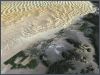
Satellite Images
Atlogis provides ideal satellite imagery for web-mapping, GIS, navigation
and print -
single scenes or complete colorbalanced global mosaics.
more»
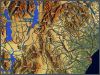
Vector-Maps
We deliver high-quality vectordata for GPS-navi- gation-systems or web-
mapping services. Our products include worldwide vector map sets and high-detailed
regional vector maps with routing functionality. more»
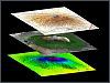
GIS and Remote Sensing Services Atlogis
uses state of the art hard- and software for analysing and processing spatial
vector and raster-data. We offer the complete palette of GIS and remote
sensing techniques to make the best out of your geodata. more»
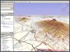
Web-GIS We
help you develop and host customized web-GIS applications for your geodata
- from company-internal intranet-GIS to high-performance Internet web mapping
services. more»
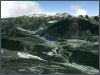
3D-Visualization / Animation
We can use our several terabytes large archive of satellite imagery and
height data to generate high-end 3D-visualizations and animations for any
place in the world. more»
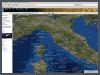
ATLOGIS
Maps Online-viewer for our satellite imagery and maps.
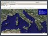
ATLOGIS
MetaMaps See Atlogis, Google, MSN and Yahoo Maps in one single viewer.